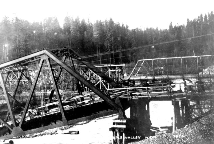
Three bridges once crossed the Cedar River in old Maple Valley, near the site of the original settlement. Two bridges belonged to railroads while the third was built by the county, originally for horse and buggy, but increasingly for automotive traffic. On Nov. 19, 1911, massive Cedar River flooding ravaged both rail crossings with only the county’s trestle bridge left standing. That bridge was later replaced by newer ones at the location where Highway 169 still crosses the river. This photo looking downstream shows the damaged Chicago, Milwaukee, & St. Paul Railway bridge in the foreground, with the county bridge still stands in the distance. In between, one can see the remaining southern trestle of the Columbia & Puget Sound (C&PS) railroad bridge, which was totally washed out. That C&PS crossing no longer exists and is now the site of the Fred V. Habenicht Rotary Park adjacent to Witte Road S.E.
The 1911 event was called the ‘granddaddy’ of Cedar River floods measuring 14,200 cubic feet per second (cfs). Today, anything greater than 5,000 cfs is considered severe flooding. As a point of reference, the flooding of Feb. 7-8, 2020 saw Cedar River reach levels of 7,590 cfs at Landsburg. Other memorable floods occurred in 1975, 1991 and 2009. However, the 1911 event became catastrophic after heavy rains precipitated a dam failure on Cedar Lake (now Chester Morse Lake). Flood waters cascaded down the river and wiped out a section of the pipeline carrying water to Seattle, depleting that city’s supply. Seattle schools, courts, and public buildings closed. Water trucks were dispatched to neighborhoods so residents could fill pitchers, pails, and buckets with water. The old pump station at Lake Washington was brought back in use, with residents advised to boil water and housewives instructed to chlorinate using a solution made from chloride of lime.
In Renton, church bells rang and the coal mine siren shrieked with residents warned to move to higher ground. The following year the city of Renton diverted the Cedar River’s flow directly into Lake Washington instead of its historic confluence with the Black River. In 1916, the Black River disappeared completely when Lake Washington was lowered nine feet and henceforth flowed out through the Ballard locks. This image #2496 comes courtesy of JoAnne Matsumura of Issaquah with historical information from the Maple Valley Historical Society. Next week, more about the 1911 flood with a photo of the downed C&PS bridge and the county bridge behind.


